北京Beijing
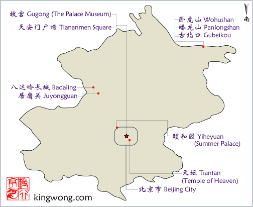
- 故宫Gugong (The Palace Museum)
- 天坛Tiantan (Temple of Heaven)
- 北京市Beijing City
- 天安门广场Tiananmen Square
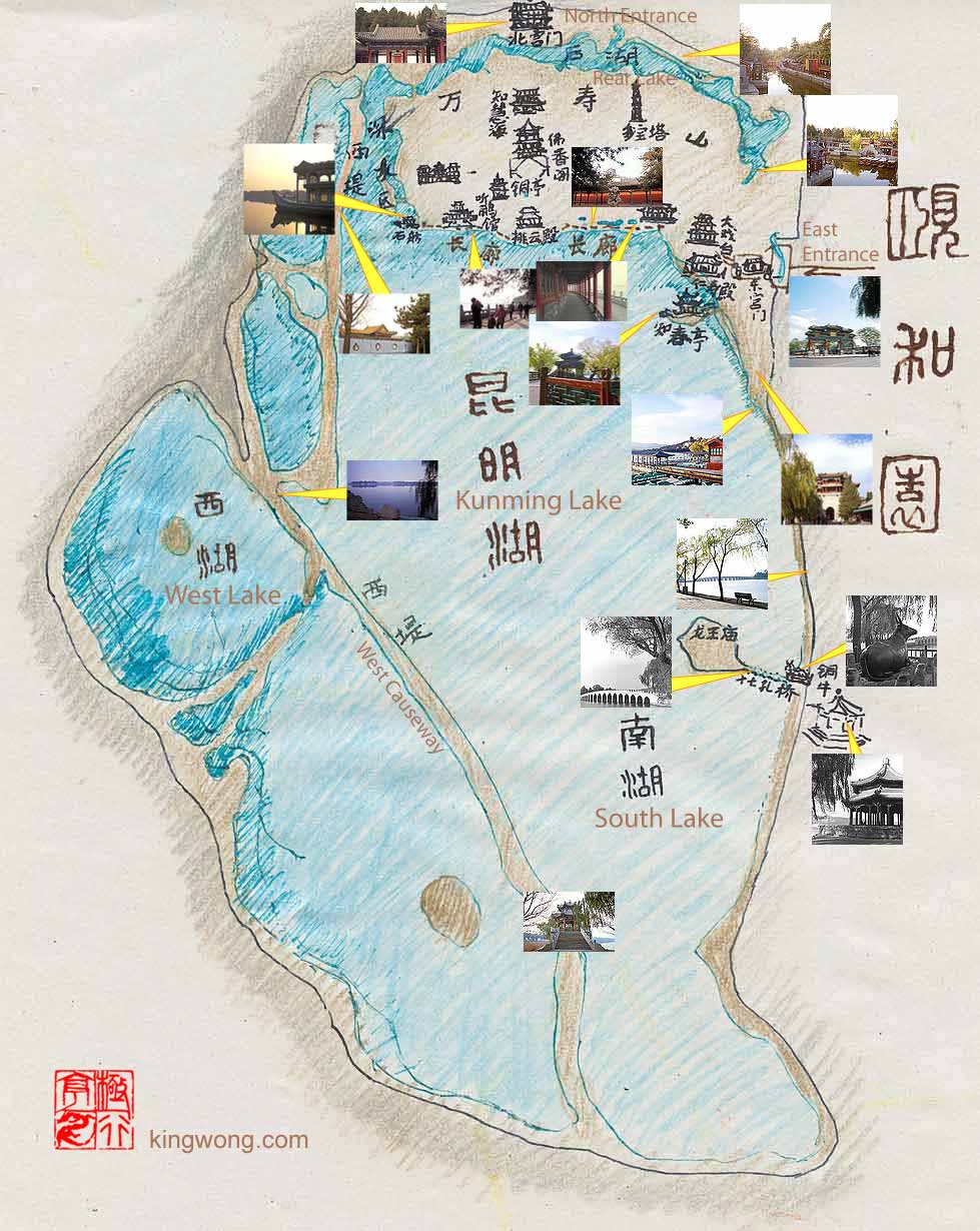
- 颐和园Yiheyuan (Summer Palace)
- 古北口镇Gubeikou Town
- 蟠龙山长城Panlongshan Great Wall
- 卧虎山长城Wohushan Great Wall
- 北京长城Beijing's Great Wall
- 北京市地图Map of Beijing city
- 北京地图Map of Beijing
- 天坛公园地图Ground Plan Map of Tiantan Park (Temple of Heaven)
北京市地图Street Map of Beijing city
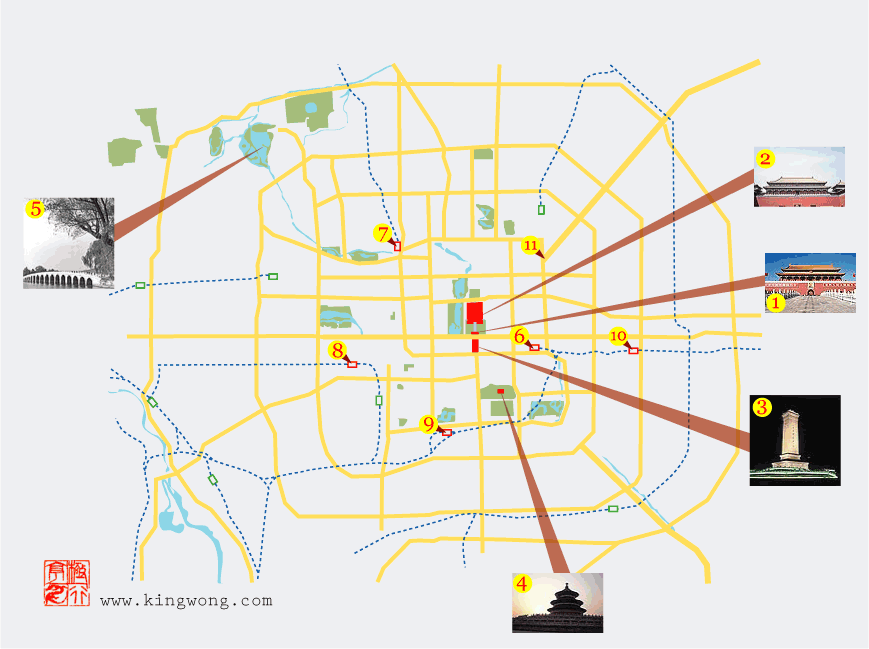
- 1. 天安门 Tiananmen Gate.
This is the first main gate before the palace complex.
- 2. 故宫 Gugong (The Palace Museum, also known as the Forbidden City).
- 3. 天安门广场 Tiananmen Square, the 440,000 square meter public space.
- 4. 天坛Tiantan ( The Temple of Heaven ).
- 5. 颐和园Yiheyuan (The Summer Palace).
- 6. 北京站Beijing Railway Station.
This is the default station, but there are 4 others - east, west, south and north stations.
- 7. 北京北站Beijing North Railway Station.
- 8. 北京西站Beijing West Railway Station.
- 9. 北京南站Beijing South Railway Station.
- 10. 北京东站Beijing East Railway Station.
- 11. 东直门Dongzhimen Gate.
This is the strategic northeast doorway of the city. From here it leads to the Capital airport as well as all the regions northeast of the capital. It becomes the major 101 National Highway.
北京地图Map of Beijing
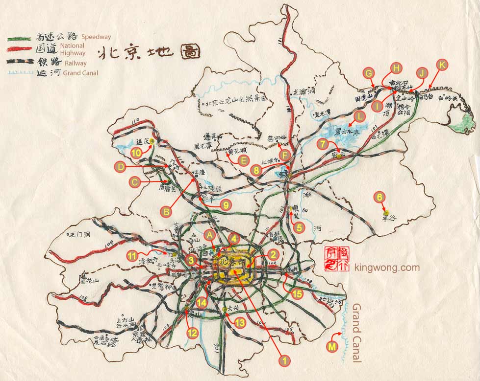
- 1. 北京市Beijing City
- 2. 朝阳Chaoyang
- 3. 石景山Shijingshan
- 4. 海淀Haiyin
- 5. 顺义Shunyi
- 6. 平谷liinggu
- 7. 密云Miyun
- 8. 怀柔Huairou
- 9. 昌平Changliing
- 10. 延庆Yanqing
- 11. 门头沟Mentougou
- 12. 房山Fangshan
- 13. 大兴Daxing
- 14. 丰台Fengtai
- 15. 通州Tongzhou
- A. 颐和园Yiheyuan ( The Summer Palace)
- B. 十三陵Ming Tombs
- C. 居庸关Juyongguan (Juyong Pass)
- D. 八达岭长城Badaling Great Wall
- E. 黄花城长城Huanghuacheng Great Wall
- F. 慕田峪长城Mutianyu Great Wall
- G. 卧虎山长城Wohushan Great Wall
- H. 古北口Gubeikou
- I. 蟠龙山长城Panlongshan Great Wall
- J. 金山岭长城Jinshanling Great Wall
- K. 司马台长城Simatai Great Wall
- L. 密云水库Miyun Reservoir
- M. 运河Grand Canal
颐和园地图Map of Yiheyuan (Summer Palace)
天坛公园地图Ground Plan Map of Tiantan Park (Temple of Heaven)
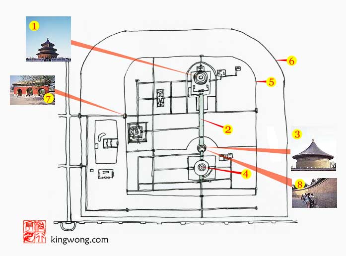
- 1. 祈年殿Qiniandian (Hall of Prayer for Good Harvests).
- 2. “神道”,“海墁大道”,“丹陛桥”
Various names given to this 360 meter long, 28 meter wide and 2.5 meter high walkway that connects the Hall of Prayer for Good Harvests on the north with the 圜丘坛Zuqiutan (Round Altar) on the south.
- 3. 皇穹宇Imperial Vault of Heaven.
It is a 19 meter high rotunda.
- 4. 圜丘坛Zuqiutan (Round Altar)
- 5. 内坛墙Tiantan's Inner Wall.
- 6. 外坛墙Tiantan's Outter Wall.
- 7. 天坛公园的一个大门
One of the gates in the complex.
- 8. 回音壁The Echo Wall.