首页Home 特别专题Special Topics 万里长城Great Wall >>古北口镇Gubeikou Town
Link to 极行亭 King Wong Stock Pictures of China Home Page, Pictures of China
Navigate by Photo
  • 西递Xidi village

  • 故宫Gugong (The Palace Museum)

  • 镇北台Zhenbeitai Tower

  • 颐和园Yiheyuan (Summer Palace)

  • 天坛Tiantan (Temple of Heaven)

  • 天安门广场Tiananmen Square

  • 宏村Hongcun village

  • 长江三峡Three Gorges

  • 南京六朝石刻Nanjing's Stone Beasts

  • 金山岭长城Jinshanling Great Wall

  • 关麓Guanlu village

  • 南屏Nanping village

  • 响沙湾Xiangshawan dunes

  • 北京市Beijing City

  • 常家庄园Chang Compound

  • 曹家大院Cao Compound

  • 希拉穆仁Xilamuren grassland

  • 平遥Pingyao

  • 嘉峪关长城Jiayuguan Pass

  • 吐鲁番Tulufan (Turfan)

  • 定边长城Dingbian's Great Wall

  • 苏公塔Sugong Ta

  • 人物People

  • 北京长城Beijing's Great Wall

  • 高昌故城Gaochang Ruins

  • 三关口长城Sanguankou Great Wall

  • 卧虎山长城Wohushan Great Wall

  • 工艺品Arts and Crafts

  • 古北口镇Gubeikou town

  • 秦长城Qin Great Wall

  • 哈密市至嘉峪关Hami to Jiayuguan

  • 城楼Buildings

  • 纽约中央公园New York Central Park

  • 景物Still Life

  • 花卉Flowers

  • 游记Travel Writings

  • 自然风景Natural Landscapes

  • 明清室内建设Ming and Qing Interiors

  • 正门,门廊Doorways

  • 建筑,设计的细节Architecture Designs and Details

  • 篆刻Seal Carving

  • 景物Things

image of a group of houses across a lake in hongcun villageimage of buildings in xidi village

Walk through anhui's pleasant villages that has over 400 years of history. See the idyllic villages of 西递Xidi, 宏村Hongcun, 南屏Nanping, and 关麓Guanlu.

古北口Gubeikou (the Old Northern Pass)

, sandwich between 山海关Shanhaiguan Pass and 居庸关Juyongguan Pass, has been historically an important strategic pass. Successive military leaders from the 北齐Northern Qi dynasty (550 - 559), who conscripted 1,800,000 men to construct 1500km of the Great Wall on its northern borders which included sections in this area, onward had given this corner a special status. It is the most accessible passage through the 燕山脉Yanshan mountain range that runs east to west, blocking the entire eastern section of northeast China. During the 元朝Yuan dynasty (1271-1368), this was the must-pass gap between Mongolia and the China's interior. Likewise, during the 清朝Qing (1644-1911), this area must be passed between Manchuria and Beijing, which is a mere 100km south. And it was through this pass that the Manchu troops walked through without a battle to set up the Qing dynasty. As late as the last century, during the Republican Era and amid the civil war period, the Japanese came down to China from Manchuria and met resistance here (1933); heavy fighting was concentrated on the 蟠龙山Panlongshan section of the Great Wall, which sits on the eastern part of the Yanshan mountain. Today, there is a stele placed in the back of the town as a memorial to the soldiers who died during the resistance.

In the past, Gubeikou had been called 虎北口Hubeikou because of the 卧虎山Wohushan (Crouching Tiger Mountain) to the west. During the 唐朝Tang (618 - 907), it got the name 虎白口Hubaikou. From then on, every successive era gave it a name. Its present name was set during the 明朝Ming dynasty (1368-1644), who built the 蟠龙山Panlongshan and 卧虎山Wohushan (Crouching Tiger Mountain) sections of the 万里长城Great Wall that rides on the ridges of the two mountains going east and west, respectively.

Gubeikou consists of several sections of the Great Wall - Wohushan, Panlongshan, 金山岭Jinshanling, and Simatai. There is one short restricted section reserved for the military; all others are linked together, except Wohushan. Beijing municipality controls all the sections but Jinshanling, which is part of 河北Hebei province. The 潮河Chaohe river runs north and south through Yanshan mountain, and passes Gubeikou on its west side by Wuhushan mountain. The river's southern end is the 密云水库Miyun reservoir, which supplies much of the drinking water to 北京市Beijing city.

Text continues below

Travel Info
image of Pingyao streetimage of the main gate tower to the Chang family's compound and gardern

The compounds and manors of the extreme wealthy in 山西Shanxi's small towns and villages. See the old town of 平遥Pingyao with well-preserved Ming and Qing city wall and street layout.

image of Tulufan's Emin Minaretimage of the ruins in Tulufan's Gaochang Ruins

See 吐鲁番Tulufan's well-known attractions -- 苏公塔Sugonta (Emin Minaret), 高昌城Gaochang Ruins, and 火焰山Huoyan Shan (Flaming Mountains).

古北口镇Gubeikou Town

  • Enlarge ImageAdd to LightboxLicense ImageAdd to Cart-Order Print

    古北口镇 Gubeikou Town

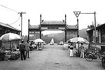
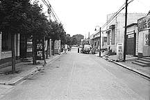
    The entrance to the town right off the national highway.

  • Enlarge ImageAdd to LightboxLicense ImageAdd to Cart-Order Print

    古北口镇 Gubeikou Town

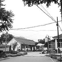
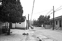
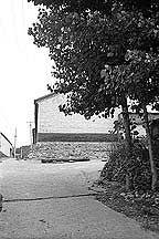
    Gubeikou is a very small town consist of a few roads.

  • Enlarge ImageAdd to LightboxLicense ImageAdd to Cart-Order Print

    古北口镇 Gubeikou Town
  • Enlarge ImageAdd to LightboxLicense ImageAdd to Cart-Order Print

    古北口镇 Gubeikou Town

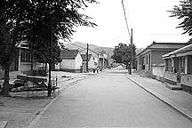
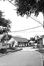
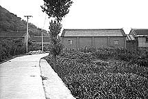
    One of the new blocks in the back of the town. The town is changing rapidly, like much of China. More and more roads are being paved with concrete. And new concrete houses line its sides.

  • Enlarge ImageAdd to LightboxLicense ImageAdd to Cart-Order Print

    古北口镇 Gubeikou Town
  • Enlarge ImageAdd to LightboxLicense ImageAdd to Cart-Order Print

    古北口镇 Gubeikou Town
  • Enlarge ImageAdd to LightboxLicense ImageAdd to Cart-Order Print

    古北口镇 Gubeikou Town
  • Enlarge ImageAdd to LightboxLicense ImageAdd to Cart-Order Print

    古北口镇 Gubeikou Town
  • Enlarge ImageAdd to LightboxLicense ImageAdd to Cart-Order Print

    古北口镇 Gubeikou Town
  • Enlarge ImageAdd to LightboxLicense ImageAdd to Cart-Order Print

    古北口镇 Gubeikou Town
  • Enlarge ImageAdd to LightboxLicense ImageAdd to Cart-Order Print

    古北口镇 Gubeikou Town
  • Enlarge ImageAdd to LightboxLicense ImageAdd to Cart-Order Print

    古北口镇 Gubeikou Town

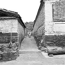
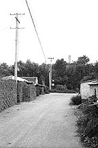
    This is the back of the town by the foot of the mountains where the 蟠龙山长城 Panlongshan Wall is.

  • Enlarge ImageAdd to LightboxLicense ImageAdd to Cart-Order Print

    古北口镇 Gubeikou Town
  • Enlarge ImageAdd to LightboxLicense ImageAdd to Cart-Order Print

    古北口镇 Gubeikou Town
  • Enlarge ImageAdd to LightboxLicense ImageAdd to Cart-Order Print

    古北口镇 Gubeikou Town

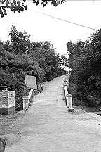
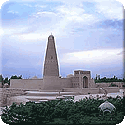
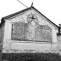
    There is a memorial obelisk nearby commemorating the locals' resistance to the invading Japanese armies.

  • Enlarge ImageAdd to LightboxLicense ImageAdd to Cart-Order Print

    古北口镇 Gubeikou Town

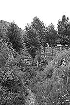
    I was searching in this treeful mountain for the path up the Wall. I climbed several peaks in vain. All I can see is the Wall on the other side.

  • Enlarge ImageAdd to LightboxLicense ImageAdd to Cart-Order Print

    古北口镇 Gubeikou Town

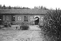
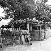
    A house I came across in the valley while I was searching for a path up the Wall.

  • Enlarge ImageAdd to LightboxLicense ImageAdd to Cart-Order Print

    古北口镇 Gubeikou Town

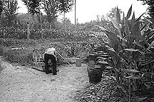
    I had a nice conversation with this local. Here the old man was preparing the meal for his pigs.

  • Enlarge ImageAdd to LightboxLicense ImageAdd to Cart-Order Print

    古北口镇 Gubeikou Town

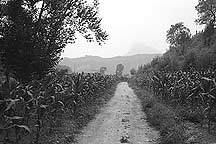
    The road out of the valley. In the distance is the 卧虎山长城 Wohushan Wall. I spent more than 2 hours trying to find a way up the 蟠龙山长城 Panlongshan Wall, from where I would move toward the 司马台长城 Simatai Wall. Having no luck and getting late, I decided to head back to town. This turned out to be better because I was able to climb the Wohushan Wall, which is a better wall than Panlongshan's.

Text continues from above.

While I was in Gubeikou town (2006), I did not planned on staying there; the place was mainly my immediate starting point for scaling the mountains and get onto the Wall, then hike to its eastern end at Simatai. Nothing, of course, was that simple. In most of the places that I travelled to, I did not planned them; if I did it would not be in great details. I depend mostly on my detail road map book of China and the local maps to find whatever is there. And I just go. So while I was in the small town, I searched for a way to get up onto the Wall. I climbed a few hills like a cat, and no matter how much of the Wall I saw, it was out of my reach. After 3-4 hours of up and down and across the cornfield valleys of these densly vegetated hills, I gave up. By now it was late afternoon, so I decided it was better to stick around in the small quiet town. This part of the town was opposite the ticket entrance to the Wohushan Great Wall section and right besides the 101 nation highway connecting 北京市Beijing city and 承德Chengde city;an arch gate at its entrance welcomes new arrivals. Inside are mostly new low block-like concrete buildings and paved roads. I rented a room, dropped off some of my stuffs and went immediately to climb Wohushan Great Wall. I only had about 2 hours of good light. But worst was my lack of film — only several frames of color film and a few rolls of black and white, mostly 35mm. While in Chengde I had used up my rolls and could not get more. Early next morning, my guesthouse's owner, Mr Pang, led me to a narrow stone stairway that leads up to the Panlongshan Great Wall; It was at the back of the town, somewhat hidden by trees and shrubs, but the path appeared to be a collective secret - something not allowed to reveal to outsiders.  

portrait of a Uygur girl

Travelogues and travel notes

Travel Information

Getting There:

From 北京市Beijing city's 东直门汽车站Dongzhimen's bus station, take the bus to 密云县Miyun county. From the county, take a minivan to Gubeikou. The Gubeikou town is right beside the 101 national highway, connecting Beijing city and 承德Chengde. So any bus to Chengde will also pass by its door.

Accomodations:

There are a lot of guesthouses in the town. Most are in the low-budget category. However, there is one that is meant for the comfort-seeker. It is right on the entrance to the 卧虎山Wohushan (Crouching Tiger Mountain) Great Wall. But I heard that it is always booked — by famous psychologists, mystic students, and celebrities. So, good luck.